Red Fox Run Nature Trail – Somerdale, Camden County, NJ
Distance – 1.0 miles total
Type – Lollipop with a loop trail
Difficulty: 2 of 10
Website – Somerdale Parks and Recreation
Open – Sunrise to Sunset.
Terrain – Woodlands
Surface – Part paved, part dirt
Trailheads – N39 50.521 W75 00.712. There’s another one in a neighborhood, but don’t use that one.
 Past the flag pole

Directions – Parking on Grant Ave just east of Browning Ave, Somerdale, NJ
Parking – Few spots in a lot, or can park along the road. I parked on Browning Ave.
Dog friendly? Unsure, not posted
Stroller friendly? Most of it would be stroller friendly
Benches? A few benches and a picnic table

Facilities?: Little free library and picnic table

Markings –None, but easy to follow
Map – No official map I found, but posted my GPS track
Description –
One reason I don’t post new trails on this blog as often as I did when I started over a decade ago is six children… that iPhones take their photos in a stupid format that’s a pain for me to convert before I can use them in posts… I secretly fight crime now instead… most new trails I find to go hike aren’t close enough I can just run out to after work. So when I find a close one that I didn’t know about, I get very excited. Some would say unreasonably excited. So excited that I rarely wait to go see them after work and just go see them the first chance I get. I have a lot of ways I find out about these new close-to-me trails, but which I mean it’s almost always a geocache.
So back in September, I solved a stupid geocaching puzzle that was listed as on a trail… and I had no idea that trail existed. I managed to last all the way until the next day, then I had to go out and hike it. It turns out this was a pretty good time to do it, as a young man had recently expanded the trail for his Eagle Project (good job Jaxon!).
Thunderstorm warning for a half hour from when I pull up? Phhhh. Thunder already in the distance? Pshaw. Off I went.
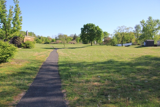
The first part is paved, and I got less excited. I mean, I’ll take the paved trails, but I like dirt ones better. This paved part was pretty short, arching to another street.


But halfway around that short arc, a sign of better things to come…
 *makes Ms. Piggy noises and yells ‘Yippie skippy!*
I decided to ignore the offshoots to the left (these seem to be the expanded part of the trail) and stay on the main pathway to start, which was pretty wide. I kept chasing a herd of deer further down the trail as I went. While this isn’t a howling wilderness, there were some nice trees along the way and I tried to keep track of birds as I went, because I am embarrassingly bad with birds and am trying to get better.


I did eventually get to a “Y” in the trail near what I suspected (correctly) was the end. I opted to go left, climb a short hill, and end up on a lawn.


 Up!
 Those clouds look unhappy.
With thunder getting a bit closer, I ducked down the nearby trailhead, which brought be down the other side of the “Y” in the trail from earlier.

 Down!

I backtracked to the smaller trails that had split left earlier (now splitting right) and took them. Not realizing about the Eagle Project yet, I figured they’d probably dead end in yards. But they did not, they looped around for quite a stretch down to a street.


This is where I found the biggest obstacle, quite a pile of vegetation that had been piled up.

But I squeezed around, the trail now cutting back toward where I’d started.


It was getting pretty dark now and the raindrops were now officially coming down. Luckily, the leaf canopy was keeping me pretty dry. I was back on the paved trail and made my way back to the trail head.


There was a pause in the rain, so I ran to my car. Not long after, we got hit with a pretty good thunderstorm, so I timed this about perfect!
Birds spotted or heard- starling, white breasted nuthatch, Carolina wren, tufted titmouse, Northern cardinal, robin, and many angry blue jays (always angry blue jays)
Ratings:
What I liked –
Lots to look at. Made some new animal friends. Trails were wide and not covered in grass, because I’ve had too many ticks and chiggers this year already.
What could be better –
Maybe a trail kiosk with a map? That’s about it, this one was pretty well put together!
Overall rating – 4 of 10 – not worth traveling much for, but a nice little trail nearby that I’ll visit again.
Nearby: Somerdale also has the Somerdale Nature Trail. Cooper River flows through the property, almost immediately after it leaves nearby Kirkwood Lake (a local favorite of ours) and not far off is Blueberry Hill in Gibbsboro.