

Galloway Township Nature Preserves – Galloway Township, Atlantic County, NJ
Distance – I did 2 miles total
Type – Lots of interlocking loops
Difficulty: 4 of 10 – can do a route that is a 1 or 2, but if you walk parts of the bike paths, it’ll be a little steeper and crazier
Website – Galloway Parks and Recreation Facilities
Open – Sunrise to Sunset.
Terrain – Hills, forests, open sand pit areas, meadows
Surface – Mostly dirt
Trailheads – N 39° 29.076 W 074° 28.033
Directions – 100 S. Old Port Republic Road, Galloway Township, NJ
Parking – Very large lot

Dog friendly? Dogs allowed on leashes
Stroller friendly? Some parts yes, others no
Benches? No benches as of when I hiked it
Facilities?: Port-a-potty

Sledding hill

Rules –

Markings – Painted blazes and metal arrows
Map –

 GPS track. Got lost off trail on the southern most part.
Description –
So there is some friendly competition between myself and Mike of Family Adventures New Jersey, as Mike (Family Adventures Mike, not me Mike, I’m not talking in the 3rd person. On this post at least. Yet.) as he is better than halfway toward hiking all 250+ South Jersey trails that I’ve done so far. The problem, of course, is that I keep hiking more trails in a desperate attempt to stay ahead of him in accordance with this blog’s super serious, ultra-dedicated purpose:
1) To seek out those trails in South Jersey that the others guys miss (or hit, we’re not particular), whether it be through a local park or deep in the Pine Barrens where the Jersey Devil steals children (other people’s children, mine are too scary for him). Then, I shall share them so the three people who read this blog can have new places to hike.
So Teacher’s Convention weekend, Mike texted me and asked if I’d done Galloway Township Nature Preserve, which he’d just driven past after doing some hiking. I had definitely not, I didn’t even have it on my list. And I love a hike I haven’t done that’s not even on my list.
I woke up Friday morning too early, so decided to sneak a hike in at Cameron Wildlife Preserve, one of my favorite places to hike in South Jersey. While there, I sat down on one of their swinging benches and scrolled through the different classes being offered that day at teacher convention… no elementary math classes… no writing classes… no history classes that don’t really have anything to do with teaching 3rd Grade but I take every chance I get anyway and then try to work it in somewhere…
So I made a fateful choice, I was going to cut convention that day for the first time in all the years I’ve gone and go to check out Galloway Township Nature Preserve instead. If my boss reads this, it is Mike’s fault. Or maybe Galloway Township’s fault. Or possibly my Scoutmaster’s fault from 30 years ago. I am innocent.
With my innocence thus established, the township bought this sand mine several years back from Ole Hansen for $1. It now contains a disc golf course, a JORBA (Jersey Off Road Bicycling Association) maintained mountain bike course, a sledding hill, and, of course, trails to walk. I pulled into the lot, set my GPS track, forgot my water bottle (whoops), and set off from the trailhead at the end of the parking lot on the northbound trails.

I immediately started running into disc golf holes along this blue blazed trail that’s clearly for bicycles. While I don’t play disc golf, they look like some serious platforms.

Not having any frisbees on me, I continued on the trail. It had some up and downs and some odd angles in places as it stayed in roughly the middle of the hill around the old sand pit, which is to be expected on a bike trail. It had a trail to the left of it and maybe some trail to the right too. When I had enough, I jumped over to the unblazed (but very clear) rim trail that runs between the blue blazed and red blazed bike trails.


 My feet and knees told me time to pick a new trail.
The rim trail quickly curved to head east along the northern border of the preserve, then curved right to start heading roughly south into the majority of the preserve.


At this point, the blue trail to my right seemed to end. However, the red trail for mountain bikes was visible to my left, generally just a dozen feet from where I was walking, but with enough little connections that I switched back and forth between them depending on which slightly different angle looked more interesting… the woods or the old sand pit.


It ended up at another overlook almost directly across from where I had parked.

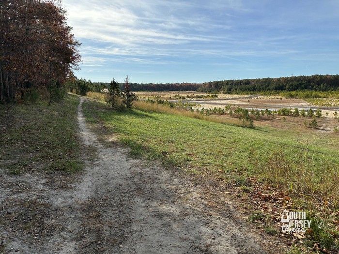

Onward! I trekked mostly on the rim trail down to the southeast corner of the preserve, where there was either a small lake or a very large puddle.


Was feeling pretty good and rounded the curve to walk the bottom stretch of trail. This is where I got myself in trouble. I was doing good, chugging along. The trail seemed to go downhill, but also left. So I stayed left. Then I saw some red trail markers. Great! I followed them. Then I hit a party spot that had lots of trash (like, insane amounts of trash)… but the trail markers seemed to evaporate. Uh oh.

 Probably should have followed this one, but I didn’t. Whoops.

 Following those markers…
 Old tree stand.
 I mean, still markers!
 Little lake in the woods… then soon after this, no more trail markers.
I decided to try to take a shortcut across a small sand pit, which looked like it would be a straight shot back to the edge of the huge sandpit. This is usually a terrible idea, but it worked for once (Serious note: I am always running a GPS track, so I’m comfortable trying this stuff a) knowing which way I’m heading thanks to the GPS and b) I can always, always, always just backtrack and follow the route I came. Also, doing this so that you don’t have to since 2013!)


 Short cut?
 It was! Arriving back at the rim trail.
The rim trail dipped down into the pit for a short stretch, then climbed back out of it for the rest of the loop.

 Into the pit!

 And back out of the pit.
I was now most of the way around the rim, and the birds kicked in for the first time. Mostly angry blue jays. It’s always angry blue jays.


I rounded the final curve and crossed the top of the sledding hill back to the car.


Good hike!
Ratings:
What I liked:
Lovely views, possibilities to change the feel of the hike up along the way by switching trails that all go in similar loops. This one will change a lot as trees grow in the old sand pit.
What Could Be Better:
An official trail map posted could be helpful!
Overall rating – 6 out of 10.
Nearby:
Nearby are the Seaview Tract Trails, Forsythe NWR, and the Port Republic Trails including the Mill Pond Trail and the trails on the west side.


Excellent find (even if it was “another” Mike that discovered it)…hey — great hiking is great hiking! Anyway, this place reminds me a lot of the English Creek Nature Reserve…sort of like Galloway Township’s answer to EHT’s Reserve. I will definitely be adding this one to my list! I’ll try to remember to review this blog again before I decide to visit so I will not “lose” the trail on the South side! 🙂
Jim
Update (1/11/26): I decided not to “wait” and hit this preserve *today*! (Since it was sort of “fresh” in my mind after reading your great blog late last week…) I pretty much started out like you did, since (I forgot) that the main trail wasn’t blazed…not even so much as a sign to mark the “official” start/end of the trail; however, I can see why blazes weren’t (or may not have be needed for the most part.) I started on the same blue-blazed mountain bike trail; I think I “lasted” longer than you did (proportionally) on the blazed trail, but after a while, I didn’t see any more blue blazes, and I did indeed see other smaller trails (probably geared to hit the disc golf “holes”), and I decided to just pick up the main trail. I totally see how it was easy to “lose” the main trail on that one section of the south end; I would go so far as to say I believe it actually doesn’t exist on the south end for a bit…like you, I followed some other trails (and even started on that one with the big “hill”), but decided to double back and simply follow “minor” trails along the rim until I picked up more of a “main” trail. I figured, if worse came to worst, I could always shoot over to Old Port Republic Road and road-walk it back to the preserve entrance…but then, it was sort of hard to get “lost” in this place…however, I still had to be careful in my selections, as some trails had wet spots when, in combination with wet sand, formed some bits of “quicksand” — didn’t want to mess with nature here!
In any case, I made it around the rest of the way with no more issues, and really enjoyed the place. (I _did_ see some of the “red” bike trail on the other side; I’m guessing those do the same thing as the ones with blue blazes, what with winding/switch-backing their way, but somewhat keeping “parallel” to the main trail.
Tell you what — I 1000% agree with you about a trail map in the future…and in addition, I would say to blaze the main trail white…or at the very least, provide guidance where the trail seems to get “lost”, or is not-so-obvious in the one section.
Again, thank you for posting this, as I always like discovering new places to hike…even if someone else does the “legwork”!
— Jim